|

| |
Automated Identification
Systems (AIS)
Check out our AIS receiving station below.
When your out sailing depending on your waters, you may sail
pass or see larger vessels such as; tour boats, passenger ships, tugboats, freighters,
barges, and larg pleasure boats. Some of the inland freighters, can be quite
large being just over 1,000 feet long, but they can still fit within the river
locks system.
Sail boaters usually maintain a healthy distance from these
large vessels, as they have; vision problems seeing over their high bows, block the wind
flow, and their stern propeller creates a large wake. The movements and
direction of these large vessels can be restricted at times due to the water
depths and the narrow navigation channels. In fog or at night it may become even
harder to visually see them on the waters, even with their navigation lights,
and
additional deck lighting.
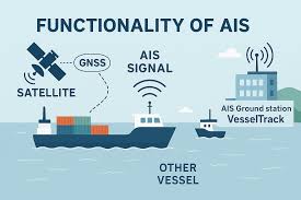 |
With today's technology
using a automated identification system called AIS. There is now a way
to electronically track these vessels as they continuously transmit
their; location, speed, and course heading. Hence anyone with a AIS receiver on board, connected to you boat's chart plotter can map and
see them, or view them online via your computer and cell phones.
There are also many
floating Buoys, called navigational aids for safety. That mark shallow shoals and river
channels which are outfitted with AIS transmitters (powered by solar panels and
batteries) to
electronically
display their locations and dangers to all vessels. In addition are land AIS
stations to provide info and mark fixed locations. |
There are many AIS plotter organizations on the internet that
showcase a detailed online map (for computers, cell phones, and tablets) displaying
hundreds of vessels and their locations. Most are operated commercially using satellites and
fixed land stations. While others are volunteer based, using dedicated volunteers.
Some
AIS volunteers (could be even yourself) help out by hosting an AIS station. They
host and use loaned equipment for free from various plotter's organizations and
simply provide the location, internet, and power. While other volunteers
purchase and use their own equipment. Some volunteers even upload their
station's data to more than one plotter organization all at the same
time.
Some online AIS Map Plotters
|
 |
How
far can AIS and Marine Radio signals transmit? On average 40-60
nautical miles over open waters, with special weather events can increase the
range at times to over 100-180 miles, There are many factors that can overall
reduce signal strength for distance; the type and gain of the antenna, the heights of
the antennas mounted on each vessel and the receiving station, weather conditions (rain, fog), high hills that can block the signals
especially when in river
channels, summer foliage on trees, and sailing in heavy waves or seas when your
antenna is rocking back and forth.
Sometimes
ships may seen to vanish and then reappear later. No their are not ghost ships,
but rather are in between the receiving AIS stations, thus the more receivers
along the shorelines, provides better AIS receiving coverage. Commercial plotters, pay
extra for satellite AIS coverage, but this is reflected in the number of ads
being displayed and the charging of membership fees to use restricted extra
features.
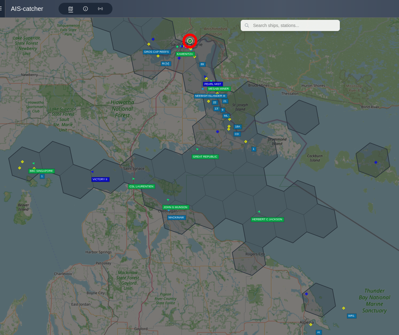
As
an AIS example, AIS.Boatnerd.com has
loaned us one of their AIS stations for the waters surrounding our area. The
setup is simple, one installs the station by; connecting the supplied coax cable
to AIS antenna, mount the antenna high up as possible to better increase the
distance, connect the other end of the coax to the AIS receiver, plug in the AIS
receiver into the raspberry pie 4 unit, and then connect the internet lan cable
and power. its a simple plug and play setup, as the raspberry pie unit is
pre-programmed and auto boots up when powered on. The AIS.Boatnerd.com administrator
can also remotely log into the raspberry unit just to perform software updates
when they are released. On AIS.Boatnerd.com
one can also turn on the layer options, to view all of the locations of the AIS receiving stations, weather reports, web cameras, ship types, and map and
charts types. If you are also interested in helping then out as a host, do
contact Boatnerd. If you want the latest on Boat news, check out their Boat News
page on boatnerd.com
|
Click to expand. |
We
additionally upload the same data to
aiscatcher.org as station
#3312, to visually see our range, and vessels. As mentioned above,
various factors can vary what is being displayed from day to day, while
these vessels are traveling between ports.
One of the busiest water systems in the Great Lakes is the Mackinaw
straits and St. Mary's River. The St. Mary's River has many sharp turns
and bends, islands, and shoals to navigate. It is a critical link that
connects Lake Superior to Lake Huron. Due to the
difference of water heights between the two lakes, all ships require
docking through the International Soo Locks. |
| More Information
A.I.S.
 | The Automated Identification System (AIS) system was created back in
2004, for large ships to continually broadcast their position (up to
50 miles) to other ships as a warning system to help avoid collisions. The AIS system uses a special transponder that transmits digital information
with each ship's configurations and movements on a VHF Marine Radios
channel. It is a requirement for all larger ships, boats, and passenger
vessels to fitted with AIS. Shore based transponders can also broadcast
warnings to ships. It has been suggested that in future this newer
technology may soon replace ships' high power radar system and shore based
lighthouses. A network of many AIS shore based receivers can forward the AIS information to a collection service and hence this new technology is
ideal for Marine Search and Rescue teams. Now with the internet, many
Volunteer organizations provide free AIS mapping of ship movements. In the
last 6 yeas, newly designed space AIS satellites have been launched and
have started monitoring data. |
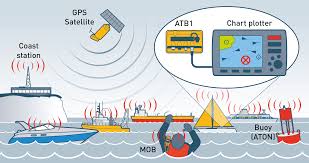
D.S.C.
| For
the Recreational Boaters, a spawned technology in a slightly different form
is known as Digital Selective Calling (DSC) that uses GPS positioning on
Marine VHF Radios. This allows public boaters to privately call other
boaters and to broadcast emergencies with GPS positions to all boaters
nearby and
is ideal for Search and Rescue Teams. DSC also helps reduce unneeded VHF radio chatter
for required commercial ships usage. Currently there are some volunteer DSC
mapping organizations that are trying to form a DSC mapping service but DSC
broadcasts are manual and non-continuous. DSC Broadcasts can be also
Fleet configured to broadcast one message to an entire fleet of ships
within range. Hence making it also ideal for local sailing and boater
clubs to have their own DSC Fleet number. |
E.P.I.R.B.
| Time proven commercial, Emergency Position Indicating
Radio Beacons (EPIRB) use a combination of satellite and
shore based receivers for reporting emergencies to Search and Rescue
Organizations. They also have the unique ability of also transmitting
a local homing signal that can be received by passing ships, when
EPIRBs are activated or immersed in water. |
Personal GPS Locators.
| New low cost personal GPS
transponders/locators are available and as an example, is
SPOT that use combinations
of satellite based network and Google Maps. |
|
|

